Classification : Classified site, Natura 2000 site, SNA
Managing organization : Monts d’Ardèche Regional Natural Park (SNA-Natura 2000), Syndicate of the Ardèche Mountain (site and house of site).
Presentation :
Located in the south of the Velay Oriental, the Gerbier-de-Joncs is a roughly prismatic phonolitic (or phonolitic needle) protrusion, typical of Pelean-type extrusive volcanism. The device is set up because of a fault which crosses the crystalline base and a small thickness of basalts of the plates. The magma is viscous, not very rich in gas and undersaturated in silica. Set up at a temperature of 600 to 800°C, it rose in the chimney to the exit point without spreading over the surface. Subsequently, the Quaternary periglacial glaciations eroded the upper part of the building, forming scree of phonolite at the foot of the protrusion. Despite the erosion, the piton has almost kept the initial diameter of the duct which gave birth to it.
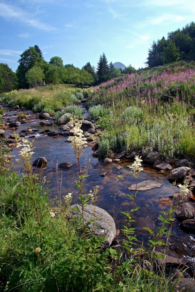
Today, rainwater infiltrates the prisms of the device and then cross the cracked basalts before reaching the crystalline base. A granite arena area sits on top of a relatively impermeable base. This more permeable zone constitutes a water table which feeds the various sources located at the foot of the Gerbier-de-Joncs. At the foot of the volcano, three sources compete for the official title of the source of the Loire, one being the most distant from the ocean, a second being the highest and the third being more abundant than the other two :
- the “geographical source”, which flows into a stone bin inside an old barn.
- the “authentic source” which corresponds rather to a monument erected in 1938 by the Touring Club of France, symbol of the Source of the Loire.
- The “true source” officially indicated on the cadastral map No. 87. It flows in a natural environment and comes out of the ground in a meadow, under a stone which bears the inscription “here begins my long race towards the ocean …”, with a basin below.
Scientific or educational interests :
Easily identifiable in the landscape, the typical form of phonolite protrusion that constitutes Mont Gerbier gives an understanding of the lava effusion mode of this type of volcanic device. The presence of the “sources” of the Loire at the foot of the protrusion makes it possible to account for the impermeability of the base on which the Gerbier de Joncs rests. The site corresponds to the watershed between the Loire and Rhône watersheds. The panorama at the summit of Mont Gerbier captures the effects of different erosion between the two watersheds : the steep slopes of the Mediterranean slope contrast with those of the ocean slope with gentle slopes translating a different geological history in the Tertiary.
Mont Gerbier is the emblematic site of the Park. It also constitutes, with the Suc du Gouleïou, the most beautiful representative example of a phonolite protrusion.
The presence of an old slate quarry on the north face of Mont Gerbier (closed in the 1940s) makes it possible to make the link with the use of rock as a building material : indeed, the evocation of the history of the site, from the formation of the dome to the exploitation and use of the phonolite for the roofs of nearby farms can constitute a common thread for understanding the landscapes, the study of the phonolite and the lauze.
The site also illustrates the history of touristic activity in France (widely interpreted in the site house) and the history of teaching geography.
Finally, it presents a certain ecological value with a rich and rare fauna and flora (moors and sub-alpine lawns with species of boreal affinity in particular).
Thematic keywords : biology, botany, cartography, ecology, entomology, study of fauna, geography geomorphology, hydrogeology, hydrology, impact on tourist numbers, paleontology, landscapes, 3D digitization topology, territorial sciences, volcanology.
Keywords typology of sites : volcanic site, panorama reading landscapes, agricultural or pastoral zone, mediation space.
Access modalities :
Free access all year round, access to the Site House from spring to fall at the request of the SMA.
Possible support : By an SMA guide, by an agent from the Parc des Monts d’Ardèche, by a geologist member of the Scientific Committee of the UNESCO Global Geopark.